
We open to provide TomoSAR services to everyone.
contact: Dinh.Ho-Tong-Minh@Irstea.fr
Context :
Numerous space-borne synthetic aperture radar (SAR) sensors are currently operating or will be launched in the near future. Consequently, there is a need to improve our knowledge of SAR data processing for land surfaces applications. In this context, we are implementing TomoSAR - a software platform, which will be actively processed from SAR, Interferometry SAR, to Tomography (so called TomoSAR). The possible applications can be as follows:
- Land displacement and topography (DEM)
- Agriculture (Land cover, rice, season mapping)
- Forestry (carbon, biomass, forest, deforestation, Tomography)
- Urban monitoring (spread, subsidence, tomography)
- All the demand SAR processing
The TomoSAR is created by D. Ho Tong Minh. This platform is based on the previous works in the frame of his research at the Politecnico di Milano and CESBIO as well as state-of-the-art algorithms published in the literature.
Current support sensors:
- Spaceborne: Sentinel-1, ERS, ASAR, Cosmos SkyMED, TerraSAR, TanDEM-X, ALOS-1/2, Radarsat-1/2, BIOMASS
- Airborne : SETHI, ESAR, FSAR
- Stripmap and TOPS modes
Demonstrations :
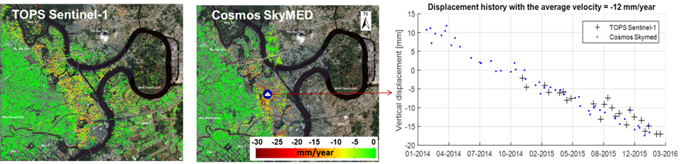
Figure 1: Good agreement between 23 images TOPS Sentinel-1 C-band and 49 images Stripmap CosmosSkyMED X-band in Ho Chi Minh City. Both are effective to detect the subsidence phenomena in 2014-2016.
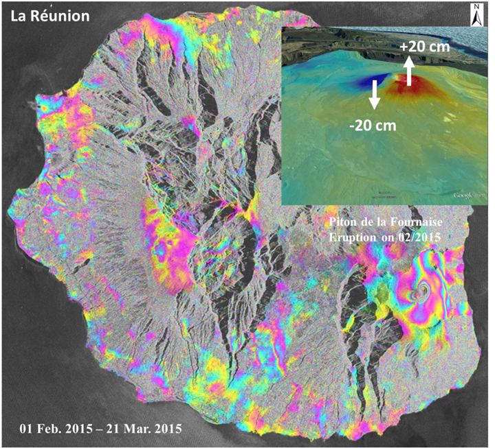
Figure 2: TOPS Sentinel-1 inteferogram (01 Feb. 2015 – 21 Mar. 2015) using 3 bursts to coverage the whole island Réunion. There is no phase jump problem even in the complex scenario (volcano) in this figure and it successfully captures the eruption in 04 February 2015 at the Piton de la Fournaise.
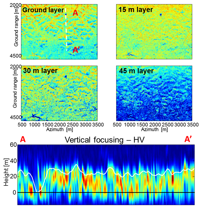
Figure 3: A multi-baseline Single Look Complex (SLC) TropiSAR 2009 SETHI data can be converted into a new multi-layer SLC data stack where each layer represents scattering contributions associated with a certain height above the ground.